• Visit Redland City Council
20 °c
Redland Bay
24 ° Sun
21 ° Mon
Saturday, April 11 2026
Redlands Coast Today - News from Redland City Council
  • Community
    • Get the Facts
    • Environment
  • Budget 2025 – 26
    • Budget 2024 – 25
    • Budget 2023 – 24
  • Disaster Management
  • Planned Burns
  • Business
  • NewslettersSubscribe
  • What’s On
  • Archive
No Result
View All Result
  • Community
    • Get the Facts
    • Environment
  • Budget 2025 – 26
    • Budget 2024 – 25
    • Budget 2023 – 24
  • Disaster Management
  • Planned Burns
  • Business
  • NewslettersSubscribe
  • What’s On
  • Archive
No Result
View All Result
Redlands Coast Today - News from Redland City Council
No Result
View All Result

Foreshore repairs ramp up after TC Alfred causes damage

28 March 2025
Reading Time: 2 mins read
A A
Foreshore repairs ramp up after TC Alfred causes damage

The landslip that occurred at Redland Bay.

Share on FacebookShare on TwitterShare on LinkedInEmail

Works are well underway to repair and rehabilitate foreshore areas damaged by the impacts of Tropical Cyclone Alfred.

Redland City Mayor and Local Disaster Management Group (LDMG) chair Jos Mitchell said crews had been working across several areas on the mainland and islands to manage erosion issues and land slippages.

“With more than 335 kilometres of coastline on Redlands Coast, severe weather events always bring the risk of impacts to exposed foreshore areas,” the Mayor said.

You may also like these stories

Walking sports pilot helps older adults step back into play

Walking sports pilot helps older adults step back into play

7 April 2026
Youth Week events activate with Council funding

Youth Week events activate with Council funding

7 April 2026

“During the cyclone we had the added complexity of higher tides and storm surge, both of which contributed to foreshore damage.

“Council takes erosion and land slip management very seriously and ensured that, as soon as it was safe to do so, crews were deployed to make these areas safe for the community.

“Effective management of erosion issues also prevents the risk of damage to surrounding assets and helps to preserve the natural beauty of our coastal areas.”

Council currently is overseeing two Shoreline Erosion Management Plans (SEMP) – Coochiemudlo Island SEMP and Amity Point SEMP on North Stradbroke Island (Minjerribah).

Both arose from the findings of the Coastal Adaptation Strategy: Part 1 – Current Erosion in 2016 report and are part of Council’s ongoing shoreline erosion mitigation actions.

Through the SEMP, an area’s erosion hotspots are identified, and recommendations are made on the most suitable management options to help protect against coastal erosion.

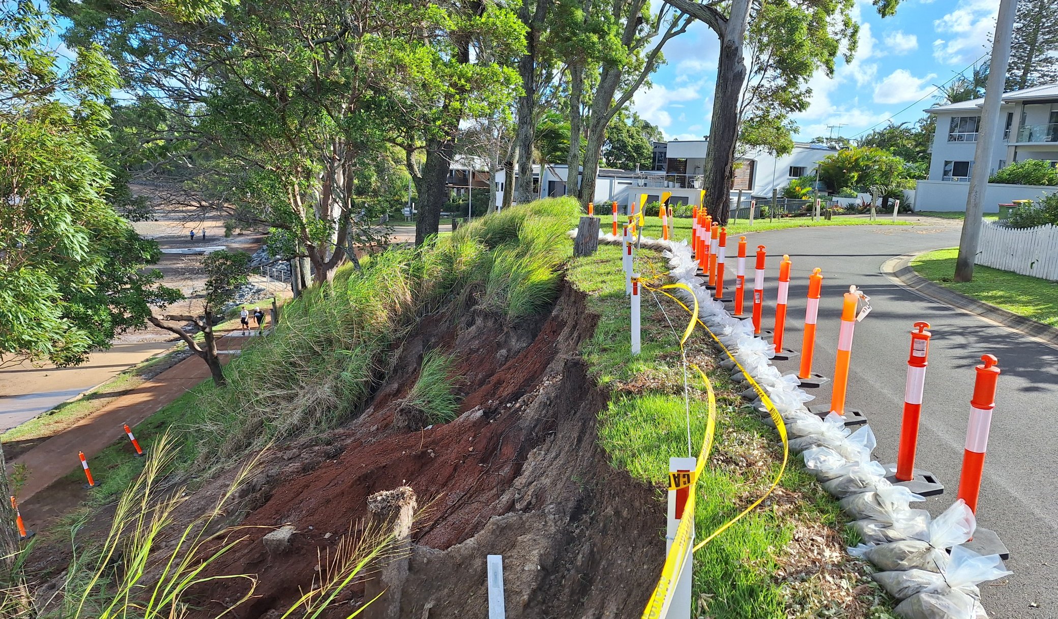
Deputy Mayor and Disaster Recovery Group chair Julie Talty said crews responded to a land slippage at Redland Bay where a large volume of soil had fallen from the slope and on to the path below.

“Council crews worked quickly to remove the debris from the path to ensure safety and accessibility for the public,” Cr Talty said.

“Soil and debris from the landslip that reached the beach will be cleared away as well.

“The slope remains off limits to the public as Council works to establish a long-term engineering solution for the site to ensure it is more resilient to future severe weather events.”

There are numerous locations across Redlands Coast prone to naturally occurring landslips. Council has a publicly available mapping system that identifies these areas. Go to City Plan – Landslide Hazard Overlay | RCC Open Data

Tags: Amity Point SEMPCoochiemudlo Island SEMPDisaster Recovery GroupLocal Disaster Management GroupNorth Stradbroke Island (Minjerribah)Shoreline Erosion Management Planstropical cyclone alfred

Related Stories

‘Painted Up’ exhibition celebrates strength of Quandamooka culture
Arts

‘Painted Up’ exhibition celebrates strength of Quandamooka culture

10 April 2026
Generating good vibes for the future of SES Redland Bay
Disaster management

Generating good vibes for the future of SES Redland Bay

9 April 2026
Planned burn: Bayview Conservation Area, Redland Bay – 10 April 2026
Planned Burns

Planned burn: Bayview Conservation Area, Redland Bay – 10 April 2026

9 April 2026
Hop into art and culture adventure on Redlands Coast
Culture

Hop into art and culture adventure on Redlands Coast

8 April 2026
Load More
Redlands Coast
Saturday, April 11, 2026
Clear
20 ° c
94%
6.1mh
31 c 19 c
Sun
27 c 16 c
Mon
Redlands Coast Today

Redland City Council acknowledges the Quandamooka People, the Traditional Owners of the land, waters, winds and seas of Redlands Coast. We acknowledge the Elders, past and present, and extend that respect to other Aboriginal and Torres Strait Islander people here.

Connect with Redland City Council

  • Archive
  • Privacy and Legal
  • Right to Information
  • Contact Us

Except where noted, content on this site is licensed under Creative Commons.

Welcome Back!

Login to your account below

Forgotten Password?

Retrieve your password

Please enter your username or email address to reset your password.

Log In

Add New Playlist

No Result
View All Result
  • Community
    • Get the Facts
    • Environment
  • Budget 2025 – 26
    • Budget 2024 – 25
    • Budget 2023 – 24
  • Disaster Management
  • Planned Burns
  • Business
  • Newsletters
  • What’s On
  • Archive

Except where noted, content on this site is licensed under Creative Commons.